| |
|
| |
| |
| |
 1983-2000:
the megalithic monuments at Changé (Saint-Piat,
Eure-&-Loir)
1983-2000:
the megalithic monuments at Changé (Saint-Piat,
Eure-&-Loir) |
 |
Begun in 1983, the excavation campaigns on the megalithic
site of Changé, Saint-Piat (Eure-&-Loir)
allowed us to contribute to obtaining a new view
of funerary rites and practices in the Neolithic.
Notably, having two closely associated monuments
on the site afforded the opportunity of reconstructing
their shared yet different past, in particular by
extending the excavation over a fairly wide area
surrounding them. |
|
Excavations in front of the "dolmen du Berceau" |
| |
| Progressively,
the excavation revealed the monuments’ complex
history—a history that was far from ended the
day the last individual was laid to rest in the “Dolmen
Petit”. If indeed the basic principle of the
condemnation of collective burial structures is today
widely accepted, the growing number of examples of
this phenomenon confirms our opinion that the understanding
we have of it is not definitive, and that only by
developing this type of problematic can we succeed
in furthering research in this domain. |
| |
 |
Gravures
sur un des piliers du dolmen du Berceau |
|
Excavation of this megalithic complex has brought
answers to a number of questions including: the choice
of site, the building materials used, the architecture
(paving, cairn), the ornamentation (symbolic engravings),
the burial function of the Dolmen Petit, the ritual
vocation of the Dolmen du Berceau, the condemnation
of the burial chamber and the new menhir, the funerary
monument (monuments to the dead or memorial), the
funerary occupation (the construction of the massive
mound of stones, the working of flint), the condemnation
of this space, the great tumulus, the reoccupation
of the site during the Gallo-roman period (the rubbish
trench) and especially, during the Merovingian era
(burial ground for some 100 individuals), then its
ultimate desertion until it was rediscovered in 1924
by Léon Petit. |
|
Coupes
reconstituées du site
(septembre 1998 - © Jean-Marc Mourain) |
| |
|
|
|
|
|
| |
This synthetic overview represents a huge amount
of work, which has already started with the drafting
of successive reports with the collaboration of
many archeologists and other specialists. Our ambition,
when we decided to undertake a second excavation
at Changé, was to improve the understanding
we have of collective Neolithic burial sites. The
development of our research allowed us to progress
well beyond that simple objective, for it is indeed
the history of mankind itself during that period
that we understand better henceforth. |
|
Summary
of the review report (1998–2000) |
Text
: Dominique Jagu |
| |
|
| |
|
|
| |
|
1998
: The Berchères sump (Berchères-la-Maingot
- Eure-&-Loir) |
|
|
The system of sumps, or conduits, part of a revised
version of a 1684 project to convey water from the Eure
River between Pontgouin and the Château of Versailles
has always been puzzling for those who took an interest
in it. Indeed, the monuments as they appear today, built
starting in 1686 and left unfinished in 1689, do not
display any structure for sealing the sump nor for accommodating
pipes that would have allowed the water arriving via
the canal from Pontgouin to span the Larris valley and
pursue its course along a second canal towards Maintenon.
An exploratory campaign was accordingly undertaken with
the objective of uncovering evidence of these structures
and thus of understanding how these sumps were intended
to function. |
| |
 |
The
entrance to the sump |
|
Two test excavations were accordingly opened in the
western sump:
- a first, designated Sector A, at the base of the shaft,
extending over its northern half;
- a second, Sector B, over the southern half of the
sump’s mouth. When Sector A was excavated, no
actual layer could be distinguished. All the sediment
was brown clay, apparently the result of the top of
the shaft having caved in, as the canal had apparently
been lined with clay. Many large clay blocks that do
not make up a uniform layer were uncovered in the course
of this excavation. Their presence in such large quantities
would tend to cast doubt upon the hypothesis of a mere
collapse, but no other explanation was found at the
time. |
| |
|
Covering the entire area of the exploratory excavation,
a pavement composed of flint nodules was exposed, atop
which a generous layer of mortar had been poured. This
pavement is comparable to that occurring close to the
sump’s entrance, once swept, save for this noteworthy
excess of mortar. A small pit about 30 cm wide was discovered
at the shaft’s entrance beside the north wall,
but its size and the fact it is isolated do not justify
assimilating it with the structure being sought. No
archeological material, aside from modern rubbish, was
unearthed in this excavation. |
| In
B Sector, a flint pavement rapidly became visible, but
a layer of mortar covers it directly beneath the sump’s
entrance, where it is out of the weather. The mortar
apparently disintegrates easily when exposed to rain.
This layer actually seems to raise this pavement to
the same level as the one, somewhat higher, inside the
sump. The exposed pavement was present throughout the
remainder of the excavation excepting the trench along
the sump’s southern wall, out of which material
had been retrieved. This trench, excavated down to a
depth of about 50 cm, yielded nothing save the information,
due to its width, that the material retrieved had been
sizeable (hewn stone blocks …). |
| |
|
Two bronze coins were also unearthed: a Louis the 16th,
from 1791, in good condition and a severely worn Napoleon
(?). Thus, none of the structures sought were identified
in this excavation. But in order to determine the full
extent of the pavement, this excavation was enlarged
by a trench continuing on from the eastern limit.This
trench, designated Sector C, enabled the pavement’s
furthest limit to be attained. It reaches virtually
up to the 17th century township road, which runs by
about 13 meters in front of the monument’s present
entrance. But this pavement does display differences.
The Sector B pavement seems to continue on eastwards
for about 1 meter into Sector C, after which the stone
blocks, consisting here of sandstone and larger in size,
form a sort of threshold. Lastly, beyond this “threshold”,
the pavement is not pointed to any considerable degree,
although a few traces of mortar are observed between
certain flint nodules. The existence of a hewn stone
block must be mentioned, set into the southern wall,
which could be the remainder of a former hewn stone
arch similar to the one marking the limit between the
shaft and the sump, or that, now removed, seen in negative
in the present entrance. The existence of the “threshold”
and the presence of this stone block would tend to suggest
that there had once been an aboveground portion of the
gallery made of brick, which ended approximately 7 m
from the present-day entrance to the underground gallery,
comprising a hewn-stone arch as entrance and another
at the join between the aboveground and the underground
parts of the gallery. This hypothesis seems to be substantiated
by the fact that the disintegration of the mortar in
the pavement beyond the “threshold” shows
that it had been exposed to the weather for a longer
period than the Sector B pavement. This aboveground
gallery would apparently have disappeared today, its
material having been retrieved after the sump had been
abandoned. |
| |
Thus, no sign of a closing structure for the monument
was discovered. It would accordingly appear that the
so-called “sump” was actually not one
at all, for it was not intended to be filled with
water. The mystery, then, remains intact. However,
a micro-topographical survey conducted at the top
of the shaft, at the close of the campaign, revealed
the existence of a micro-relief that may have been
a vestige of the structure we had been looking for.
The beginning of the piping, then, would seem to have
been situated at the end of the canal, ahead of the
mouth of the shaft. The pipes would simply have run
down this shaft and through the entire monument, the
purpose of which would merely have been that of a
monumental service and maintenance gallery, on the
scale of a masterwork of courtiers destined for the
château of the Sun King. |
|
Summary
of the excavation report (1998) |
Text
: David Tosna |
|
| |
|
| |
|
2000
: the Saint Nicolas chapel (Maintenon - 28) |
|
An
exploratory campaign was carried out by a working
party from the megalithic site of Changé (Saint-Piat)
inside the Saint Nicolas chapel in Maintenon for the
purpose of discovering the original pavement, prior
to a possible restoration.
|
|
| |
The
Saint Nicolas chapel
on the square of the
Château of Maintenon |
| |
|
Two exploratory excavations were opened for the purpose
of uncovering this original pavement: one in the vicinity
of a step at the junction between the choir and the
nave, the other near the entrance, encompassing the
chapel’s lateral turret. We resolved to excavate
only the southern portion of the chapel on the assumption
that its floor-plan is symmetrical. Thus we opened the
areas excavated from the middle axis all the way to
the southern wall. The excavation of the choir and of
the nave led to the discovery of a center aisle paved
in sandstone. These sandstone sets are identical in
size and shape to those forming the pavement of the
choir, which has always been exposed. These two pavements
would accordingly seem to have been laid down at the
same period. This aisle has been damaged by an excavation
where it joined the step to the choir. The fill of the
excavation contains notably a large slab once part of
another pavement currently present at the entrance.
This excavation may be evidence of earlier digging conducted
with a view to locating the tomb of Jean Cottereau,
who had had the chapel built. The side aisle that was
examined presents a limestone mortar floor surmounted
here and there by a thin layer of pulverulent brick.
In all probability, the flooring at this spot once consisted
of bricks or tiles. The presence of a brick fragment
incrusted in the limestone mortar up against the edge
of the center aisle would appear to support this hypothesis.
By removing this limestone mortar down to the foundation
level, we were able to determine that there was no trace
of any previous pavement. Only a jumbled layer of fragmented
brick was uncovered, which would seem to be a layer
designed to drain the foundations. |
| |
|
An attentive cleaning of the portion of the choir pavement
included in the excavation revealed its layout. We also
exposed the pavement corresponding to the position of
the canon’s stalls, with a deposit of various
materials that we were able to date to the 19th century
thanks to objects they contained. The cleaning of the
choir step also allowed us to reveal the position of
a chancel bar as well as traces of a grillwork on a
fragment of threshold affording access to the choir.
The
excavation opened near the entrance did not allow us
to locate the center aisle found in the previous excavation.
We nevertheless did discover traces of the orange-colored
mortar that made up the pointing and the top of the
pavement of the center aisle. Very probably the stones
were removed during the Revolution when the chapel was
deconsecrated, but the mortar beneath was not completely
extracted with them. The limestone mortar was not able
to be located with certainty, for the whole excavation
presents many disturbed areas (most important among
which is the foundation of the turret). |
| |
The chapel’s current threshold is composed of
large sandstone slabs which may have been added during
the Revolution to compensate for the removal of the
center aisle. One of these flagstones was apparently
used to fill up the hole made in the center paving
in the first excavation. |
| |
|
The turret’s earthen floor was also examined,
but it yielded no significant information. About 20
cm lower, the equivalent of a step, a grey mortar floor
was uncovered. We were, on the contrary, able to date
this turret to the period ca. 1785-1792, because it
is not shown on a blueprint from the archives dated
1785, and its erection in an anticlerical Revolutionary
context seems out of the question. A walkway would appear
to have been laid down to access it, for we uncovered
an under-pavement, grey mortar shelf to one side of
two flagstones of different origin. |
| |
 |
A
child’s grave |
|
| |
|
However, a certain number of graves were identified.
We excavated one of these: in it lie the remains of
a child aged about 18 months who apparently was buried
some time after the turret was built (for the tomb was
dug into the mortar of the walkway leading to the turret).
Two other complete graves were left untouched, for they
were only discovered at the end of the campaign. Also,
four others are merely assumed, for only the edges of
the pits were uncovered, the bones having disappeared.
It seems obvious that these few burials represent only
a small portion of the necropolis constituted by the
Saint Nicolas chapel and that an anthropologist might
in future excavate so as to study a population dating
to the 16th through the early 19th centuries. |
|
Summary
of the excavation report (2000) |
Text
: David Tosna |
|
| |
|
| |
|
2000
: the modern-day menhir of Mévoisins (Mévoisins
- 28) |
|
At the request of the township of Mévoisins,
a small village near Maintenon, and of its mayor,
Guy Dubois, a modern-day menhir was erected by its
inhabitants using prehistoric methods. |
| The
purpose of this undertaking was to commemorate the advent
of the third millennium whilest at the same time honoring
the first farmers of the Beauce region. |
|
The
modern-day menhir of Mévoisins
|
| |
|
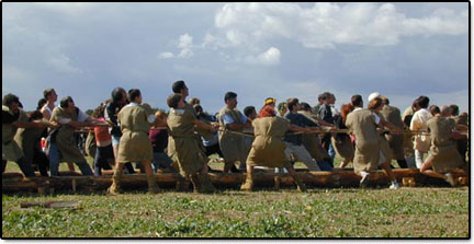
Installed on a sledge rolling on logs, a ten-ton piece
of sandstone was pulled 55 meters during the afternoon
of September 2, 2000, then upended into the hole prepared
to receive it. |
 |
Upending
the menhir |
|
|
Two hundred fifty participants were required to achieve
this ambitious project of experimental archeology. |
|
To conserve the memory of this undertaking, it was
decided that the complete list of the inhabitant of
Mévoisins and of other participants, as well
as miscellaneous objects typifying our era (computer,
mobile phone, year 2000 coins, etc.) were to be buried
at the foot of this new menhir, the first to be erected
in the third millennium. |
A
prehistoric-style feast for 750 banqueters (with wild
boar roasted on spits) brought this manifestation
to a fitting close. |
|
(september
2, 2000) |
Text
: Dominique Jagu |
|
| |
|
| |
|
| |
| |
|